
Practice News
How we are revolutionising our building surveys with drone expertise

by AHR
The Civil Aviation Authority (CAA) has reported a steady rise in the registration of drone users, with 601,000 active users as of the end of June 2024 – a 17.1% increase from 2023.
While advancements in technology in recent years have seen a rise in commercial drone use across a wide range of industries, their integration into building surveying is transforming the service, surpassing traditional methods in many aspects with unparalleled accuracy, efficiency and significantly reduced risks to health and safety.
This, paired with enhancements to the outputs that can be achieved, is firmly cementing the ever-increasing demand for surveys undertaken by drone, sometimes referred to as Unmanned Aerial Vehicles (UAVs).
Our in-house geomatic consultancy team regularly delivers this service, offering our clients, and our teams of architects and building consultants, a significant number of benefits.
So, what are the advantages of drone surveys and how might we be able to support your next project?
Enhancing cost efficiency and time savings
The use of sophisticated drone technology enables us to capture detailed imagery and information from ‘hard to reach’ areas that would traditionally require the use of scaffolding or cherry pickers.
This means we can provide our clients significant time and money saving benefits, removing the need for cumbersome and time-consuming safety and access equipment.
As part of a larger scheme which aimed to collate information about their sites, review flood risk assessments and re-establish legal boundaries, Network Rail appointed us to carry out a range of specialist surveying services.
At our client’s East London site, this included using sophisticated drone technology and co-ordinated Ground Control Points (GCP), to collate accurate information.
 Drone image combined with the topographical survey
Not only were we able to capture information from this vast location efficiently, we also created a scaled image of the full site, delivered at survey grade accuracies and tolerances – including part of the 2012 Olympic Stadium on the North boundary.
Significantly reducing health and safety risks
By operating an UAV from ground-level, our highly skilled surveyors eradicate the risk of any injury to themselves and our clients.
Where traditionally a surveyor would be required to physically review the condition of a roof, a drone can capture high-definition images and 4K video footage which can all be reviewed from the ground.
This is particularly useful when reviewing an estate with multiple buildings and for High-Rise and Higher-Risk Buildings (HRBs) which present considerable risk.
We have recently seen an increase in demand for drone surveys where access to buildings is restricted, or sometimes impossible, owing to major health and safety risks on buildings deemed too unsafe.
This, in part, is due to tightening public sector budgets for estate maintenance, resulting in a backlog of essential repairs and a growing issue with deterioration.
Supporting the protection of heritage buildings
As the use of drones removes the requirement for scaffolding, ladders and cherry pickers, risk of damage from contact to a building is significantly reduced. This is particularly useful when working on listed or historically important buildings which, by their nature, need to be protected.
Another benefit of using a drone to capture, often intricate, details of historic buildings is their ability to capture the information at exceptional speed, without any compromise to the accuracy or quality.
For example, we captured Lichfield Cathedral’s complex Gothic architecture using drone technology.
The information was used to create 2D CAD drawings of the floors, elevation, sections, and roof of the Grade I listed medieval building, ultimately informing our client’s maintenance plans.
 Capturing ornate details is no problem for a drone
Capturing thermal data to support decarbonisation
Supporting our clients in planning maintenance and improvement works which are designed around improving thermal efficiency and enhancing the sustainability of their sites, our drones can capture thermal imaging data.
This uses heat mapping to accurately depict where a building is losing heat, helping our clients to make informed decisions, whilst applying a ‘whole-building’ approach.
We provided thermal imaging services to assist Urmston Grammar School in achieving their energy efficiency targets by providing management support for the procurement and delivery of a Heat Decarbonisation Plan (HDP), working closely with consultants Hulley and Kirkwood.
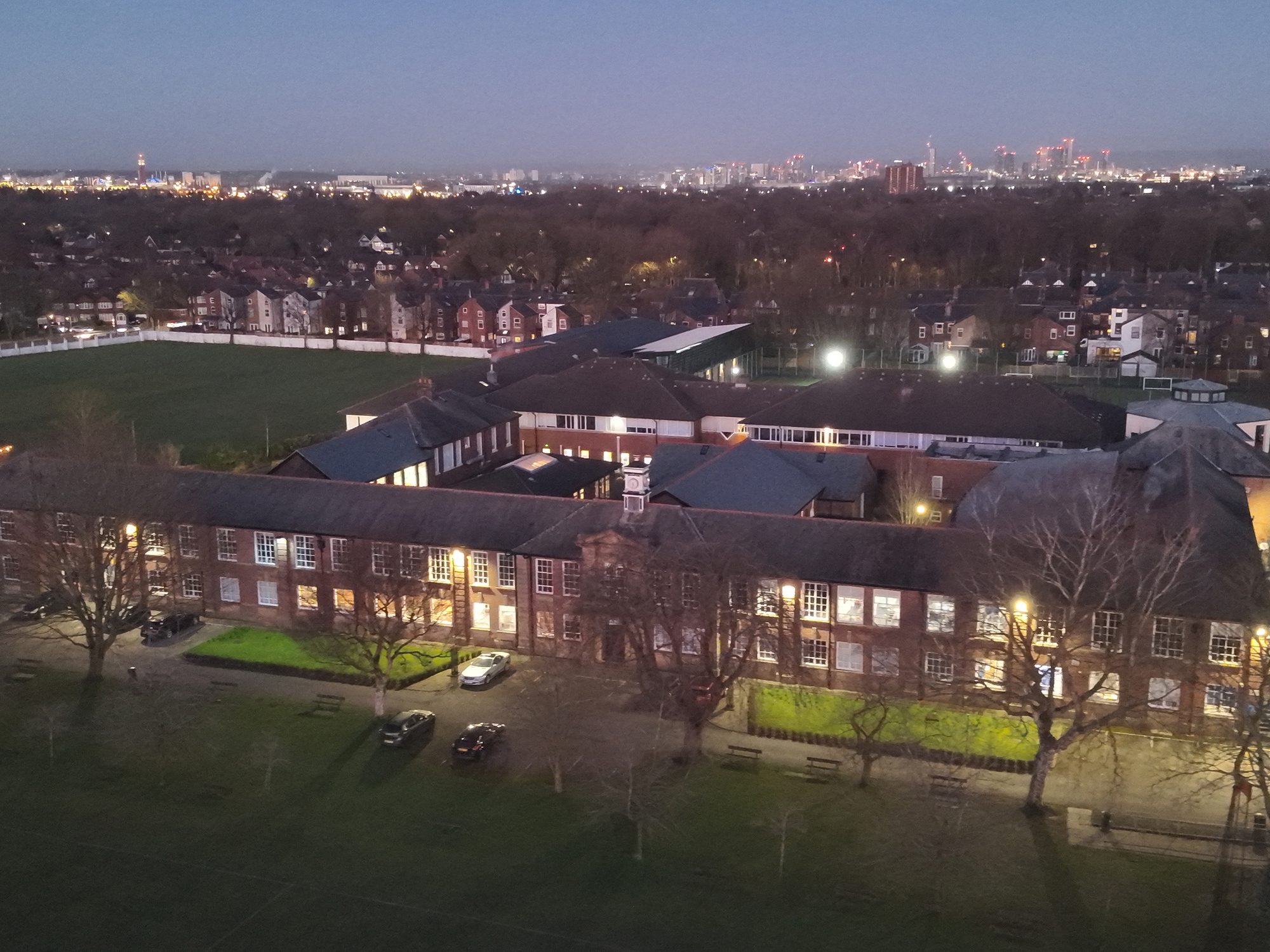
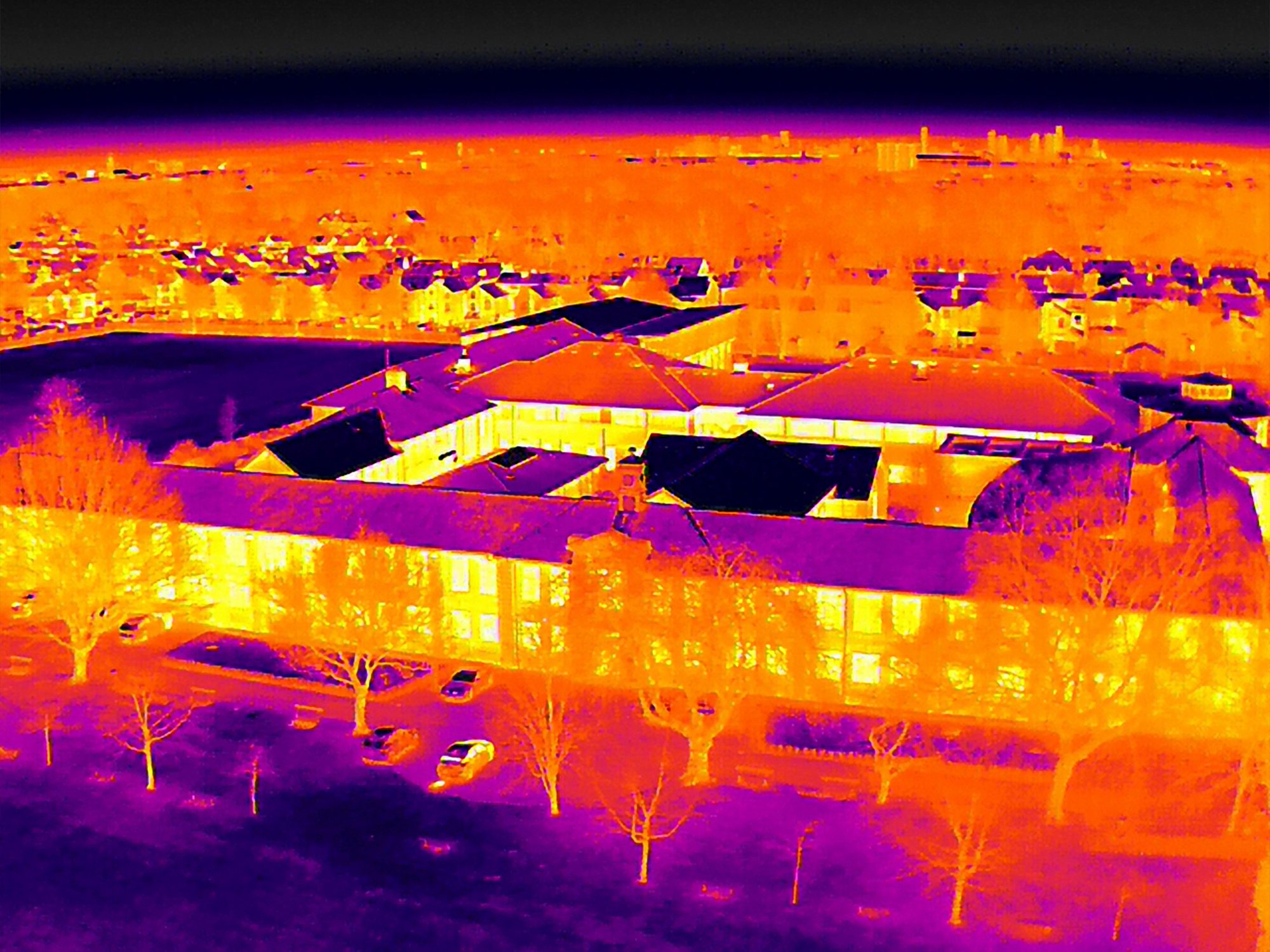


Our in-house geomatic consultancy team has carried out thermal imaging surveys, using infrared technology to detect heat emissions and create a heat map showing clearly where the building had inefficiencies, such as heat loss due to poor insulation, as well as air and water leaks.
This information was incorporated into the HDP to ensure thermal efficiency and therefore maximise carbon reduction.
Accessing hard-to-reach areas
Drones can reach tricky areas much easier than traditional surveying methods. For example, a drone can be flown into narrow spaces and above buildings to review the condition of roofs.
This was particularly useful at our appointment at University College London (UCL).
Owing to its central London location, the building is in prominent public view and surrounded by four city centre roads, all of which would traditionally make access to carry out a review of the six-storey building’s roof extremely difficult.


Adding to complications, the adjacent UCL Hospital requires access for blue light vehicles at all times, meaning roads had to remain accessible throughout any works.
Using a drone, these complications were eliminated, and we were able to efficiently and safely capture HD images detailing the condition of each individual area of the roof, informing a wider scheme of repair works.
Could your project benefit from a drone survey? Visit our geomatic consultancy page to find out more, or get in touch with us directly.
Share on
Related Projects

Network Rail Site Surveys
As part of a larger scheme, our geomatic consultancy team carried out topographical surveys, geomatic scanning, CCTV and drone surveys.

Lichfield Cathedral
We were commissioned to create 2D CAD drawings of the floors, elevation, sections, and roof of the historic medieval Cathedral in Staffordshire, UK.

Cruciform Building, Drone Survey
Ensuring the preservation of the historic structure, we carried out a review of the roof and will manage the ensuing repair works.
Related News

Supporting the development and sustainability of your estate with thermal imaging technology
Practice News
7 Oct 24

Reflecting on the building consultancy projects that have shaped and supported our local communities this year
Practice News
9 Dec 24

How we’re supporting our clients’ maintenance and development plans through sophisticated MEP mapping services
Practice News
9 Dec 24